By Victoria Sanchez/OU News Service
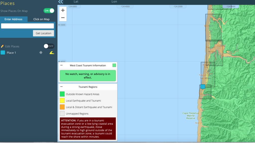
The University of Oregon has partnered with the state to build a web-based platform that directs Oregon coastal communities to evacuation routes in the event of a tsunami.
The UO InfoGraphics Lab and Location Innovation Lab have been working with the Oregon Department of Geology and Mineral Industries and the Northwest Association of Networked Oregon Observing Systems to develop the platform. The website is now live and ready for residents to use.
Joanna Merson, cartographic developer for the InfoGraphics Lab and leader of the project, said the website adds an additional layer of security for resident’s tsunami evacuation preparation.
“The idea behind these evacuation routes is that people will be evacuating on foot,” Merson said. “Because of the high potential for hazards and congestion on the roads, people may not be able to drive away from a tsunami; instead they are encouraged to walk or run to high ground.”

The tool will allow evacuees to locate their home or workplace on the map and make a plan for future evacuations. Visitors to the site are able to pick locations along the Oregon coast and view which areas fall into earthquake and tsunami regions, as well as the regions outside known impact zones. From there, users can generate the closest tsunami evacuation routes from any location within the mapped region.
Residents can chart the amount of time they have to evacuate from their current location; how long it will take to evacuate if they walk, jog or run; and where the best evacuation assembly area is located.
The InfoGraphics Lab specializes in cartography, data visualization and geospatial analysis, and it works on a variety of statewide mapping projects. Merson said the Location Innovation Lab was critical to setting up the interactive hosted map service for this project.
When developing the models for the project, Merson said having the flexibility to add in local trails and other roads to the existing road network was important to the team. Based on data the state has collected on existing local structures, such as identifying which bridges may not hold during a tsunami, Merson’s team was able to create a model that redirects people around those potentially unreliable structures, which is a critical piece of the project.
“Local residents and visitors need to know what to do if they feel an earthquake,” Merson said. “Many people know they need to have a ‘go bag,’ and this tool allows them to add to their plan.”
Advanced preparation is critical for navigating natural disasters such as tsunamis and earthquakes. Although the evacuation routes can be accessed on the fly, Merson said the best way to use the information is in preparation planning.
The team also is revamping physical copies of local evacuation routes that will then be available at local businesses.
“I think with climate change, the pandemic and the fires, risk is at the front of people’s minds,” Merson said. “With the increasing frequency of disasters that we’re seeing, it’s really important that we communicate well as scientists, and that’s something we aim to do in the InfoGraphics lab. We’re thinking about what design choices help make finding understandable.”


